Текст The Thames с переводом.
The Thames
Темза
| London would not be London without the River Thames. It flows 215 miles across the English countryside and then through the heart of the great city before it reaches the sea. The Thames has played an extremely important part in making England what it is today. | Лондон не был бы Лондоном без реки Темзы. Она течет на 215 миль через английскую сельскую местность и затем через сердце великого города, до того как она впадет в море. Темза сыграла чрезвычайно большую роль в становлении Англии в ее теперешнем состоянии. | |
| England had very few roads in the past, so the Thames provided a major highway between London and many parts of the country. People could also send supplies of food and other goods to and from London by boat. In times of war, London was protected from sea attacks because they built castles and forts at the mouth of the river. People from the London area got their drinking water from the Thames, and thirsty cows and sheep were a common sight along its banks. | Англия в прошлом имела очень мало железных дорог, поэтому Темза была главным путем между Лондоном и многими частями страны. Люди также могли отправлять запасы еды и других продуктов в Лондон и из него на корабле. В военное время Лондон был защищен от атак с моря, потому что были построены замки и форты у устья реки. Люди с территорий Лондона брали питьевую воду из Темзы, а также на ее обоих берегах обычным зрелищем были жаждущие воды коровы и овцы. | |
| With the Industrial Revolution in the 18th century, the Thames became one of the busiest waterways in the world. Factories made and exported goods of all kinds. So people became rich and many of them built beautiful houses along the banks of the river. The famous writer Charles Dickens spent part of his childhood there and later wrote about the Thames in his books. | С промышленной революцией 18 века Темза стала одним из самых нагруженных путей в мире. Заводы производили и экспортировали товары всех видов. Поэтому люди богатели, и многие из них строили красивые здания вдоль берегов реки. Знаменитый писатель Чарльз Диккенс провел часть своего детства там и позже писал о Темзе в своих книгах. | |
| Today the Thames has become a symbol of London, just as much as Big Ben or Buckingham Palace. If you take a stroll along its banks, you’ll have a day full of pleasant surprises. You can admire bridges built in many different architectural styles. The most famous one is probably Tower Bridge which actually opens up 1,000 times a year to let ships through. Or you might be lucky enough to see London’s rowing event, the Oxford and Cambridge Boat Race, which takes place on the river every spring. Whether you’re a Londoner or a visitor, the Thames will always have something to offer you. | Сегодня Темза стала символом Лондона, так же как и Биг-Бен или Букингемский Дворец. Если вы отправитесь на прогулку по ее берегам, то у вас будет день полный приятных сюрпризов. Вы можете любоваться мостами, построенными во многих архитектурных стилях. Наверное, одним из самых знаменитых является Тауэрский мост, который открывается 1000 раз в год, чтобы пропустить корабли. Или вам может повезти увидеть Лондонскую греблю, лодочные состязания Оксфорда и Кембриджа, которые происходят на реке каждую весну. Будь вы лондонцем или посетителем, у Темзы всегда найдется, что вам предложить. |
Источник: Spotlight, 8 класс, модуль 6 culture corner
Продолжим читать тексты про Лондон и Великобританию на английском языке. Сегодня ознакомимся с описаниями реки Темзы и часов Биг Бен.
The Thames

The Thames is not a long river. It is three hundred and thirty kilometres long and it runs into the sea. The English people call it “the Father of London”. London began on the Thames. When we go in a ship up the Thames we pass under London Bridge, the Tower Bridge and others. There is a museum of old ships on the Thames. These ships are from the history of Great Britain. One of these ships, the “Discovery”, went to the South Pole in 1901 — 1904.
If we go down the Thames we pass the port of London and get to Greenwich — a very old town. We can see the place where the Greenwich Meridian passes.
Переведем:
Темза
Темза — не длинная река. Она длиной триста тридцать километров и впадает в море. Англичане называют ее «Отец Лондона». Лондон возник на Темзе. Когда мы поднимаемся на корабле вверх по Темзе, мы проходим под Лондонским Мостом, Башенным Мостом и другими. На Темзе музей старых кораблей. Эти корабли из истории Великобритании. Один из этих кораблей, «Discovery», ходил к южному полюсу в 1901-1904 годах.
Если мы идем вниз по Темзе, мы проходим Лондонский порт и добираемся до Гринвича — очень старого города. Мы можем видеть места, где проходит Гринвичский Меридиан.
Теперь текст про Биг Бен:
Big Ben

The Houses of Parliament is a very large building which stands near the Thames. There are two tall towers at the corners of the building and one of them is the Clock Tower.
The English people built the tower and the clock in 1858. The clock has four faces and a very big loud bell. The bell weighs 13 tons. The man in charge of the building was Sir Benjamin Hall. This man was very tall, and the workers and his friends called him Big Ben. So they called the bell Big Ben too. Sometimes people call the clock and the Clock Tower Big Ben.
The people of London who live near the Houses of Parliament can hear the sound of the bell every hour. Other people hear it on the radio. On New Year’s night people come to the Clock Tower to see the New Year in.
Переведем с английского:
Биг Бен
Здание парламента — очень большая постройка, расположенная возле Темзы. В ней есть две высоких башни по углам постройки и одна из них — часовая башня.
Англичане построили башню и часы в 1858 году. У часов четыре стороны и очень большой, громкий колокол. Колокол весит тринадцать тонн. Человеком, отвечающим за строительство, был Бенджамин Холл. Этот человек был очень высоким, и рабочие и его друзья называли его Биг Бен. Так они называли колокол Биг Бен тоже. Иногда люди называют часы и часовую башню Биг Бен.
Люди Лондона, которые живут возле здания парламента, могут слышать звук колокола каждый час. Другие люди слышат его по радио. В новогоднюю ночь люди приходят к часовой башне увидеть новый год.
The Thames
The Thames is not a long river. It is three hundred and thirty kilometres long and it runs into the sea. The English people call it “the Father of London”. London began on the Thames. When we go in a ship up the Thames we pass under London Bridge, the Tower Bridge and others. There is a museum of old ships on the Thames. These ships are from the history of Great Britain. One of these ships, the “Discovery”, went to the South Pole in 1901 — 1904.
If we go down the Thames we pass the port of London and get to Greenwich — a very old town. We can see the place where the Greenwich Meridian passes.
Переведем:
Темза
Темза — не длинная река. Она длиной триста тридцать километров и впадает в море. Англичане называют ее «Отец Лондона». Лондон возник на Темзе. Когда мы поднимаемся на корабле вверх по Темзе, мы проходим под Лондонским Мостом, Башенным Мостом и другими. На Темзе музей старых кораблей. Эти корабли из истории Великобритании. Один из этих кораблей, «Discovery», ходил к южному полюсу в 1901-1904 годах.
Если мы идем вниз по Темзе, мы проходим Лондонский порт и добираемся до Гринвича — очень старого города. Мы можем видеть места, где проходит Гринвичский Меридиан.
The Thames is not a long river. It is three hundred and thirty kilometres long and it runs into the sea. The English people call it “the Father of London”. London began on the Thames. When we go in a ship up the Thames we pass under London Bridge, the Tower Bridge and others. There is a museum of old ships on the Thames. These ships are from the history of Great Britain. One of these ships, the “Discovery”, went to the South Pole in 1901 — 1904.
If we go down the Thames we pass the port of London and get to Greenwich — a very old town. We can see the place where the Greenwich Meridian passes.
Перевод:
Темза — не длинная река. Она длиной триста тридцать километров и впадает в море. Англичане называют ее «Отец Лондона». Лондон возник на Темзе. Когда мы поднимаемся на корабле вверх по Темзе, мы проходим под Лондонским Мостом, Башенным Мостом и другими. На Темзе музей старых кораблей. Эти корабли из истории Великобритании. Один из этих кораблей, «Discovery», ходил к южному полюсу в 1901-1904 годах.
Если мы идем вниз по Темзе, мы проходим Лондонский порт и добираемся до Гринвича — очень старого города. Мы можем видеть места, где проходит Гринвичский Меридиан.
London developed as a centre of international trade because of its position on the River Thames. By the nineteenth century it was one of the busiest docklands in the world, handling Britain’s huge import and export trade. The river is no longer important for business, and is now used mainly by pleasure boats.
London Bridges
A wooden bridge, called London Bridge, existed from Roman times until the twelfth century, when it was rebuilt in stone with a street of houses along it. This structure lasted for more than 600 years. The old stone bridge became London’s most famous landmark. Until 1750 it was the only bridge over the Thames in London. It gradually crumbled and was demolished. A new bridge was built in 1831 to replace the old one. This in turn was demolished in 1967 and rebuilt in Lake Havasu City, USA, as a tourist attraction. The present London Bridge opened in 1973.
Bridge Stories
Old London Bridge was built on stone arches resting on a series of piers. The houses along it often had shops at street level. At one end there was a stone gateway, where the heads of executed traitors were stuck on top of poles to rot away.
Theroad over the bridge was only about 4m wide between the shops. It was so narrow it often jammed with people, horses and carts. In 1733 a «keep left» rule was enforced to keep the traffic moving. This became the rule of the road in Britain. The bridge acted as a dam and slowed down the river, so that during winter it often froze upstream. Sometimes Frost Fairs were held, when stalls and entertainments were set up on the ice – puppet shows, football games and even barbecues.
River Sights
There are many things to see and do along the Thames. To relieve overcrowding on the River in the 1800s big new docks were built. They were deep-water basins connected to the Thames by canals and locks. Now they have become office, housing and leisure areas. Saint Katharine’s Dock. Saint Katharine’s Dock is now a marina, with shops and cafés around it. There is a lock connecting the dock to the Thames, and you can sometimes see it being used by pleasure boats going in and out.
Kathleen and May.In Saint Mary Overy Dock you can visit the Kathleen and May, which has recently been restored. She is one of the last remaining wooden sailing schooners, and once traded around the British coast, with four seamen on board.
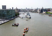
HMS Belfast.HMS Belfast was built in 1938 and served in the Second World War. It is moored permanently on the Thames and is open as a Museum. You can visit different parts of the ship, including the engine room and the Captain’s bridge.
Victoria Embankment.In the 1800s three embankments were built along the Thames, with gas mains, sewage pipes and underground railways hidden inside them. There are pavements, benches and strings of lighs laid out along them.
Cleopatra’s Needle.Cleopatra’s Needle on Victoria Embankment is an ancient Egyptian monument, shipped to Londonin the 1870s. Victorian objects are buried underneath it, including newspapers, a railway timetable and a box of cigars.
Tower Bridge
Tower Bridge is the only Thames bridge which can be raised. The road over the bridge is built on two central sections called bascules, which open two or three times a week to let ships through.
The Thames
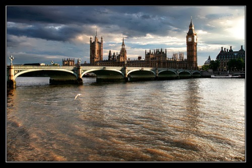
The River Thames is one of the sights of London. Tourists come to admire the beauty of Cleopatra’s Needle, Big Ben and the Houses of Parliament. In fact the river isn’t just a part of the scenery. Without the river London wouldn’t exist. Let’s look back into history.
Two thousand years ago, in A. D. 43 a Roman army decided to cross the Thames at a point where a bridge could be built. That was the beginning of the City of London.
The Thames connected the settlements of the Romans at Kent and at Colchester. All foreign traffic and goods had to cross the Roman bridge, that’s why the nearby land grew into a key port, thus increasing trade with the Continent.
Over the next five hundred years, London exported the nation’s wool, cattle and imported fine clothes from Flanders, wine from France, furs from Scandinavia. The tradesmen formed guilds, which protected their interests and strengthened London’s position as a commercial centre.
The 16th century brought new horizons in exploration and conquest by sea. But there appeared some problems. The twenty arches of London Bridge disturbed the river’s current, causing «rapids». The ships were forced to stop below the bridge, paying small boats to take their goods upstreams.
To solve this problem the first docks were built in the 17th century at Rotherhithe. In the 18th and 19th centuries the docks were also built on the Isle of Dogs. In 1908 the Port of London Authority was formed to look after them.
The importance of the Thames was great. London has changed greatly over the years.
At Chelsea Bridge two periods of history stand facing each other. On the North bank is the Royal Hospital. This house was built in the 18th century by Sir Christopher Wren.
On the South bank there is Battersea power station, built to provide electricity for Londoners.
If we move downstream, we’ll come to Vauxhall Bridge. This area contains factories and offices.
Under Lambeth Bridge, the river flows on past the Victoria flower gardens towards Westminster Bridge. Here are the Houses of Parliament and Big Ben, built in the 19th century in the gothic style.
From this point all along the embankment run the Embankment Gardens, with their tramps, memorials and flowers. At the riverside itself there is a row of charming Victorian lamp-posts decorated with ferocious- looking dolphins. Even the public benches are decorated with winged sphinxes. You can also admire Cleopatra’s Needle, a huge obelisk carved in Ancient Egypt and given to Queen Victoria and Great Britain in 1820. It was placed by the river in 1878, and a «time box», containing objects typical of that time was buried beneath it.
Near Waterloo Bridge, on the South bank of the river is a group of modern, concrete buildings. These include the Royal Festival Hall, Queen Elizabeth Hall, and the new National Theatre. Waterloo Bridge is concrete and modern, but it replaces an older bridge built to mark the anniversary of the Battle of Waterloo. The lampstandards along the bridge were made from guns captured at the battle.
As you pass the widest of London’s bridges — Blackfriars Bridge — you see the dome of St. Paul’s.
The next bridge is Southwark Bridge, which leads to Southwark Cathedral (it is as beautiful as Westminster Abbey). Then you come to London Bridge. Originally it was made of wood. The first stone bridge wasn’t built until 1176. A new London Bridge replaced it in 1831, but you wouldn’t find this London Bridge now either, as it was sold to America in 1972. It was taken there stone by stone to be reassembled as a tourist attraction. The British have a modern replacement now.
But the bridge that symbolizes London to most people is Tower Bridge.
Much of London’s wealth has been generated by the trade and industry brought by the river. The river became badly polluted in Victorian times. Industrial waste flowed freely into it. There was a terrible smell. All the fish died.
Since the 1950s, new laws have controlled industrial waste and sewage levels in the Thames. Now the river is much less polluted. Fish have returned to the cleaner water. Plea-sure boats sail from Westminster and Charing Cross piers, taking summer visitors to Greenwich and Hampton Court, Palace.
To protect London from tide the Greater London Council decided to build a barrier across the river at Woolwich. The floodgates lie on the river bed in normal weather, but can be raised to shut off dangerously high waters.
London could never have lived without the Thames.
EXERCISES
I. Answer the questions.
1. Why were the first docks at Rotherhithe built?
2. Who was the architect of the Royal Hospital?
3. What anniversary does Waterloo Bridge mark?
4. Which bridge is the widest?
5. Where can you see London Bridge?
6. Which bridge symbolizes London?
II. Fill in the gaps.
1. … years ago the Romans decided to cross the Thames.
2. In the 18th and 19th centuries the . . . were built on the Isle of Dogs.
3. The area of Vauxhall Bridge contains . . . and ….
4. The first Waterloo Bridge was built to mark ….
5. In 1972 a new London Bridge was sold to . . . .
6. The bridge that symbolizes London is ….
7. To protect London from tide a . . . across the river was built.
Answers
II. 1. 2,000; 2. docks; 3. factories and offices; 4. the anniversary of the Battle of Waterloo; 5. America; 6. Tower Bridge; 7. barrier.
(Великобритания: Тексты для устных ответов и письменных работ на английском языке. Авт.-сост. И. Ю. Баканова)
The Thames is a major river flowing through southern England. While best known because its lower reaches flow through central London, the river flows through several other towns and cities, including Oxford, Reading,Windsor and Berkshire.
The river gives its name to the (Wikipedia page Thames Valley), a region of England centred around the river between Oxford and West London, the Thames Gateway, the area centred around the tidal Thames, and the Thames Estuary to the east of London.
Summary[]
The River Thames is the second longest river in the United Kingdom and the longest river entirely in England, rising at Thames Head in Gloucestershire, and flowing into the North Sea at the Thames Estuary. It has a special significance in flowing through London, the capital of the United Kingdom, although London only touches a short part of its course. The river is tidal in London with a rise and fall of 7 metres (23 ft) and becomes non-tidal at Teddington Lock. The catchment area covers a large part of South Eastern and Western England and the river is fed by over 20 tributaries. The river contains over 80 islands, and having both seawater and freshwater stretches supports a variety of wildlife.
The river has supported human activity from its source to its mouth for thousands of years providing habitation, water power, food and drink. It has also acted as a major highway both for international trade through the Port of London, and internally along its length and connecting to the British canal system. The river’s strategic position has seen it at the centre of many events and fashions in British history, earning it a description as “Liquid History”. It has been a physical and political boundary over the centuries and generated a range of river crossings. In more recent time the river has become a major leisure area supporting tourism and pleasure outings as well as the sports of rowing, sailing, skiffing, kayaking, and punting. The river has had a special appeal to writers, artists, musicians and film-makers and is well represented in the arts. It is still the subject of various debates about its course, nomenclature and history.
Physical and natural aspects[]
Course of the river[]
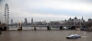
The monument at the official source of the Thames. River Thames Flood Barrier The Thames passes by some of the sights of London, including the Houses of Parliament and the London Eye
The Thames has a length of 215 miles (346 km). Its usually quoted source is at Thames Head (at grid reference ST980994), about a mile north of the village of Kemble and near the town of Cirencester, in the Cotswolds. However, Seven Springs near Cheltenham, where the river Churn rises, is also sometimes quoted as the Thames’ source, as this location is furthest from the mouth both in distance along its course and as the crow flies and adds some 14 miles (22 km) to the length. The springs at Seven Springs also flow throughout the year, while those at Thames Head are only seasonal.
The Thames flows through or alongside Ashton Keynes, Cricklade, Lechlade, Oxford, Abingdon, Wallingford, Goring-on-Thames, Reading, Henley-on-Thames, Marlow, Maidenhead, Windsor, Eton, Staines, Weybridge and Thames Ditton before entering the Greater London area. The present course is the result of several minor redirections of the main channel around Oxford, Abingdon and Maidenhead and more recently the creation of specific cuts to ease navigation.
From the outskirts of Greater London, the river passes Hampton Court, Kingston, Teddington, Twickenham, Richmond (with a famous view of the Thames from Richmond Hill), Syon House and Kew before flowing through central London. In central London, the river forms one of the principal axes of the city, from the Palace of Westminster to the Tower of London and was the southern boundary of the mediaeval city, with Southwark on the opposite bank.
Once past central London, the river passes between Greenwich and the Isle of Dogs, before flowing through the Thames Barrier, which protects central London from flooding in the event of storm surges. Below the barrier, the river passes Dartford, Tilbury and Gravesend before entering the Thames Estuary near Southend-on-Sea.
Catchment area and discharge[]
The river drains a catchment area of 4994|sqmi or 5924 sqmi if the River Medway is included as a tributary. (Dot & Ian Hart (2001–5). The River Thames — Its geology, geography and vital statistics from source to sea. Retrieved November 1, 2005.)
The non-tidal section[]
Locks and weirs on the River Thames
The Jubilee River at Slough Weir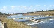
Brooks, canals and rivers, within an area of convert|3841, combine to form 38 main tributaries feeding the Thames between its source and Teddington Lock, the tidal limit. Before Teddington Lock was built in 1810-12, the river was tidal as far as Staines. The tributaries include the rivers River Churn, River Leach, River Cole, Wiltshire, River Coln, River Windrush, River Evenlode, River Cherwell, River Ock, River Thame, River Pang, River Kennet, River Loddon, River Colne, Hertfordshire, River Wey and River Mole, Surrey. In addition there are many backwaters and distributaries and some man-made channels such as the Longford River.
More recently, an artificial secondary channel to the Thames, known as the Jubilee River, was built between Maidenhead and Windsor for flood relief, being completed in 2002.
More than half the rain that falls on this catchment is lost to evaporation and plant transpiration. The remainder provides a water resource that has to be shared between river flows, to support the natural environment and navigation, and the population’s needs for water supplies to homes, industry and agriculture.
The non-tidal section of the river is managed by the Environment Agency which has the twin responsibilities of managing the flow of water to control flooding, and providing for navigation. The volume and speed of water down the river is managed by adjusting the gates at each of the weirs and at high water levels are usually dissipated over flood plains adjacent to the river. Occasionally flooding is unavoidable, and the Agency issues Flood Warnings. During heavy rainfall the Thames occasionally receives raw sewage discharge due to sanitary sewer overflow.
The tidal section[]
-

London Stone at Staines, built in 1285 marked the tidal limit of the Thames and the City of London’s jurisdiction
The lower course of the Thames in 1840
Below Teddington Lock (about convert|55|mi} upstream of the Thames Estuary) the river is subject to tidal activity from the North Sea. Before the lock was installed the river was tidal as far as Staines. London, capital of Roman Britain, was established on two hills, now known as Cornhill and Ludgate Hill. These provided a firm base for a trading centre at the lowest possible point on the Thames.
(Peter Ackroyd London:The Biography Vintage 2001) A river crossing was built at the site of London Bridge. London Bridge is now used as the basis for published tide tables giving the times of high tide. High tide reaches Putney about 30 minutes later than London Bridge, and Teddington about an hour later. The tidal stretch of the river is known as «the Tideway».
The principal tributaries on the Tideway include the rivers Brent, Wandle, Effra, Westbourne, Fleet, Ravensbourne (the final part of which is called Deptford Creek), Lea, Roding, Darent and Ingrebourne. At London, the water is slightly brackish, with sea salt, being a mix of sea and fresh water.
This part of the river is managed by the Port of London Authority. The flood threat here comes from high tides and strong winds from the North Sea, and the Thames Barrier was built in the 1980’s to protect London from this risk.
Islands[]
Temple Island — the start of the Henley Royal Regatta course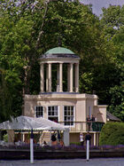
The river Thames contains over 80 islands ranging from the large estuarial marshlands of the Isle of Sheppey, Isle of Grain and Canvey Island to small tree-covered islets like Rose Isle in Oxfordshire and Headpile Eyot in Berkshire. Some of the largest inland islands — Formosa Island near Cookham and Andersey Island at Abingdon — were created naturally when the course of the river divided into separate streams, while Desborough Island, Ham Island at Old Windsor and Penton Hook Island were artificially created by lock cuts and navigation channels. Chiswick Eyot] is a familiar landmark on the Boat Race course, while Glover’s Island forms the centrepiece of the spectacular view from Richmond Hill. Islands with a historical interest are Magna Carta Island at Runnymede, Fry’s Island at Reading and Pharaoh’s Islandnear Shepperton. In more recent times Platts Eyot at Hampton was the place where Motor Torpedo Boats were built, Tagg’s Island near Molesey was associated with the impresario Fred Karno, and Eel Pie Island at Twickenham was the birthplace of the South East’s R&B music scene.
Geological history[]
Lardon Chase
The River Thames can first be identified as a discrete drainage line as early as 58 million years ago, in the late Palaeocene Period Thanetian Stage. Until around half a million years ago, the Thames flowed on its existing course through what is now Oxfordshire, before turning to the north east through Hertfordshire and East Anglia and reaching the North Sea near Ipswich. At this time the river system headwaters lay in the English West Midlands and may, at times, have received drainage from the North Wales Berwyn Mountains. Arrival of an ice sheet in the Quaternary Ice Age, about 450,000 years ago, dammed the river in Hertfordshire and caused it to be diverted onto its present course through London. This created a new river route aligned through Berkshire and on into London after which the river rejoined its original course in southern Esse], near the present River Blackwater estuary. Here it entered a substantial freshwater lake in the southern North Sea basin. The overspill of this lake caused the formation of the Dover Straits or Pas-de-Calais gap between Great Britain and France. Subsequent development led to the continuation of the course which the river follows at the present day.
At the height of the last ice age around 12000 years ago, Britain was connected to mainland Europe via a large expanse of land known as Doggerland in the southern North Sea basin. At this time, the Thames’ course did not continue to Doggerland, but was aligned southwards from the eastern Essex coast where it met the Rhine, the River Meuse and the River ScheldtCite error: Invalid <ref> tag; invalid names, e.g. too many
In addition the Thames is host to some invasive crustaceans including Signal crayfish and Chinese Mitten Crab.
On January 20 2006 a northern 16-18 ft (5 m) bottle-nosed whale was spotted in the Thames and was seen as far upstream as Chelsea. This is extremely unusual because this type of whale is generally found in deep sea waters. Crowds gathered along the riverbanks to witness the extraordinary spectacle. But it soon became clear there was cause for concern, as the animal came within yards of the banks, almost beaching, and crashed into an empty boat causing slight bleeding. Approximately 12 hours later, the whale was believed to be seen again near Greenwich, possibly heading back to sea. There was a rescue attempt lasting several hours, but it eventually died on a barge. (See Wikipedia page [1])
Human aspects[]
The River Thames has served several roles in human history, being an economic resource, a water highway, a boundary, a fresh water source, also a source of food and more recently a leisure facility.
Human history[]
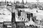
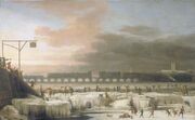
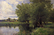
The Tower, with Tower Bridge built 800 years later An engraving by Claes Van Visscher showing Old London Bridge in 1616, with Southwark Cathedral in the foreground The Frozen Thames, 1677. 19th century painting «Haymaking on the Thames» by John Clayton Adams Wallingford Bridge and St Peter’s Church The Thames at Hampton The Thames as it flows through London, with the Isle of Dogs in the centre.


There is evidence of human habitation living off the river along its length dating back to Neolithic times.[1] The British Museum has a decorated bowl (3300-2700 BC), found in the River at Hedsor, Buckinghamshire and a considerable amount of material was discovered during the excavations of Dorney Lake.[2] A number of Bronze Age sites and artifacts have been discovered along the banks of the River including settlements at Lechlade, Cookham and Sunbury-on-Thames. Some of the earliest written accounts of the Thames occur in Julius Caesar’s account of his second expedition to Britain in 54BC[3] when the Thames presented a major obstacle and he encountered the Iron Age Belgae/|Belgic tribes the Catuvellauni and the Atrebates along the river.
Under the Emperor Claudius in AD 43 the Romans occupied England and, recognising the River’s strategic and economic importance, built fortifications along the Thames valley including a major camp at Dorchester, Oxfordshire. Two hills, now known as Cornhill and Ludgate Hill, provided a firm base for a trading centre at the lowest possible point on the Thames called Londinium where a bridge was built. The next Roman bridge upstream was at Staines (Pontes) to which point boats could be swept up on the rising tide with no need for wind or muscle power. Many of the Thames’ riverside settlements trace their origins back to very early roots and the suffix — “ing” in towns such as Goring and Reading, Berkshire, owe their origins to the Saxons. Recent research suggests that these peoples preceded the Romans rather than replaced them.[4] The river’s long tradition of farming, fishing, milling and trade with other nations started with these peoples and has continued to the present day. Competition for the use of the river created the centuries-old conflict between those who wanted to dam the river to build millraces and fish traps and those who wanted to travel and carry goods on it. Economic prosperity and the foundation of wealthy monasteries by the Anglo-Saxons attracted unwelcome visitors and by around AD 870 the Vikings were sweeping up the Thames on the tide and creating havoc as in their destruction of Chertsey Abbey.
Once William I of England had won total control of the strategic Thames Valley he went on to invade the rest of England. He had many castles built, including those at Wallingford, Rochester, Kent, Windsor, Berkshire and most importantly the Tower of London. Many details of Thames activity are recorded in the Domesday Book. The following centuries saw the conflict between King and Barons coming to a head in AD 1215 when King John was forced to adhere to the Magna Carta]] on an island in the Thames at Runnymede. This granted them among a host of other things under Clause 23 the right of Navigation. Another major consequence of John’s reign was the completion of the multi-piered London Bridge which acted as a barricade and barrage on the river, affecting the tidal flow upstream and increasing the likelihood of freezing over. In Tudor and Stuart times the Kings and Queens loved the river and built magnificent riverside palaces at Hampton Court, Kew, Richmond on Thames, Whitehall and Greenwich.
The 16th and 17th centuries saw the City of London grow with the expansion of world trade. The wharves of the Pool of London were thick with seagoing vessels while naval dockyards were built at Deptford. The Dutch navy even entered the Thames in 1667 in the raid on the Medway.
A cold series of winters led to the Thames freezing over above London Bridge, and this led to the first Frost Fair in 1607, complete with a tent city set up on the river itself and offering a number of amusements, including ice bowling. In good conditions barges travelled daily from Oxford to London carrying timber and wool, foodstuffs and livestock, battling with the millers on the way. The stone from the Cotswolds used to rebuild St Paul’s Cathedral after the Great Fire in 1666 was brought all the way down from Radcot. The Thames provided the major highway between London and Westminster in the 16th and 17th centuries and the clannish guild of watermen ferried Londoners from landing to landing and tolerated no outside interference. In AD 1715 Thomas Doggett was so grateful to a local waterman for his efforts to ferry him home pulling against the tide, that he set up a rowing race for professional watermen known as “Doggett’s Coat and Badge”.
By the 18th century, the Thames was one of the world’s busiest waterways, as London became the centre of the vast, mercantile British Empire and progressively over the next century the docks expanded in the Isle of Dogs and beyond. Efforts were made to resolve the navigation conflicts up stream by building locks along the Thames. After temperatures began to rise again, starting in 1814, the river stopped freezing over completely.[5] The building of a new London Bridge in 1825, with fewer pillars than the old, allowed the river to flow more freely and reduced the likelihood of freezing over in cold winters.[6]
The Victorian era was an era of imaginative engineering. In the ‘Great Stink’ of 1858, pollution in the river reached such proportions that sittings at the House of Commons at Westminster had to be abandoned. A concerted effort to contain the city’s sewage by constructing massive sewers on the north and south river embankments followed, under the supervision of engineer Joseph Bazalgette. Meanwhile, similar huge undertakings took place to ensure water supply, with the building of reservoirs and pumping stations on the river to the west of London. The embankments in London house the water supply to homes, plus the sewers, and protect London from flood. The coming of rail transport] added both spectacular and ugly railway bridges to fine range of earlier road bridges but reduced commercial activity on the river. However sporting and leisure use increased with the establishment of regattas such as Henley Royal Regatta and The Boat Race. On 3 September 1878, one of the worst river disasters in England took place, when the crowded pleasure boat {{SS|Princess Alice collided with the Bywell Castle, killing over 640 people.
The growth of road transport and the decline of the Empire, in the years following 1914, reduced the economic prominence of the river. During World War II the protection of the Thames was crucial to the defence of the country. Defences included the Maunsell forts in the estuary and barrage balloons to cope with the threat of German bombers using the distinctive shape of the river to navigate during The Blitz. Although the Port of London remains one of the UK’s three main ports, most trade has moved downstream from central London. The decline of manufacturing industry and improved sewage treatment have led to a massive clean-up since the filthy days of the late 19th and early- to mid-20th centuries, and aquatic life has returned to its formerly ‘dead’ waters. Alongside the river runs the Thames Path, providing a route for walkers and cyclists.
In the early 1980s a massive flood-control device, the Thames Barrier, was opened. It is closed several times a year to prevent water damage to London’s low-lying areas upstream (as in the 1928 Thames flood for example). In the late 1990s, the Jubilee River was built, which acts as a flo]] channel for the Thames around Maidenhead and Windsor.[7]
Origin of the name[]
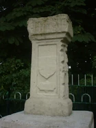
Statue of Old Father Thames at St John’s Lock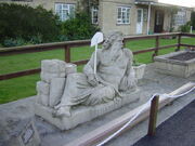
The Thames, from Middle English Temese, is derived from the Celtic name for the river, Tamesas (from *tamēssa),[8] recorded in Latin as Tamesis and underlying modern Welsh Tafwys «Thames». The name probably meant «dark» and can be compared to other cognates such as |Irish teimheal and Welsh tywyll «darkness» Proto-Celtic *temeslos) and Middle Irish teimen «dark grey»,[8] though Richard Coates[9] mentions other theories: Kenneth H. Jackson ref>London in London</ref> that it is non Indo-European (and of unknown meaning), and Peter Kitson’s[10] that it is IE but pre-Celtic, and has a name indicating muddiness from a root *tã-, ‘melt’.
The river’s name has always been pronounced with a simple t; the [Middle English spelling was typically Temese and Celtic languages TAmesis. The th lends an air of Ancient Greek to the name and was added during the Renaissance, possibly to reflect or support a belief that the name was derived from River Thyamis in the Epirus (region region of Greece, whence early Celtic tribes were erroneously thought to have migrated.
Indirect evidence for the antiquity of the name ‘Thames’ is provided by a Roman potsherd found at Oxford, bearing the inscription Tamesubugus fecit (Tamesubugus made this). It is believed that Tamesubugus’s name was derived from that of the river.[11]
The Thames through Oxford is often given the name the River The Isis, although historically, and especially in Victorian era, gazetteers and cartographers insisted that the entire river was correctly named the River Isis from its source until Dorchester, Oxfordshire. Only at this point, where the river meets the River Thame and becomes the «Thame-isis» (subsequently abbreviated to Thames) should it be so-called; Ordnance Survey maps still label the Thames as «River Thames or Isis» until Dorchester. However since the early 20th century, this distinction has been lost in common usage outside Oxford, and some historians suggest the name Isis—although possibly named after the Egyptian mythology goddess of Isis —is nothing more than a contraction of Tamesis, the[Latin] (or pre-Roman Celtic) name for the Thames.
Richard Coates suggests that while the river was as a whole called the Thames, part of it, where it was too wide to ford, was called *(p)lowonida. This gave the name to a settlement on its banks, which became known as Londinium, from the Indo-European roots *pleu- «flow» and *-nedi «river» meaning something like the flowing river or the wide flowing unfordable river.[9]
For merchant seamen, the Thames has long been just ‘The London River’. Londoners often refer to it simply as ‘the river’, in expressions such as ‘south of the river’.[12]
The active river[]
One of the many piers for joining sightseeing boat trips.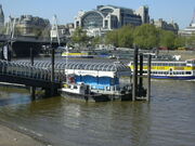
One of the major resources provided by the Thames is drinking water provided by Thames Water whose area of responsibility covers the length of the River Thames. The Thames Water Ring Main is the main distribution mechanism for water in London with one major loop linking the Hampton, Walton-on-Thames, Ashford, Surrey, and Kempton Water Treatment Works to central London.
In the past, commercial activities on the Thames included fishing (particularly eel trapping), coppicing willows which provided wood for many purposes including osiers, and running watermills for flour and paper production and metal beating. These activities have disappeared, although there was a proposal to build a hydro plant at Romney Lock to power Windsor Castle. As of January 2008, this scheme appears to have been abandoned.
The Thames is popular for riverside housing whether in high rise flats in central London or chalets on the banks and islands up stream. The river has its own residents dwelling on houseboats, typically around Brentford and Tagg’s Island
Transport and tourism[]
The tidal river[]
London
In London there are many sightseeing tours in tourist boats, past the more famous riverside attractions such as the Houses of Parliament and the Tower of London as well as regular riverboat services co-ordinated by London River Services.
The upper river[]
Passenger services are operated in summer along the entire non-tidal river from Oxford to Teddington. The two largest operators are Salters Steamers and French Brothers. Salters operate services between Folly Bridge, Oxford and Staines. The entire journey takes 4 days and requires several changes of boat.[13] French Brothers operate passenger services between Maidenhead and Hampton Court. [14] Along the course of the river a number of smaller private companies also offer river trips at Wallingford, Reading and Hampton Court.[15] Many companies also provide boat hire on the river.
The leisure navigation and sporting activities on the river have given rise to a number of dependent businesses including boatbuilding, marinas, ships chandlers and salvage services.
Police and lifeboats[]
The river is policed by five police forces. The Thames Division is the River Police arm of London’s Metropolitan Police, while Surrey Police, Thames Valley Police, Essex Police and Kent Police have responsibilities on their parts of the river outside the metropolitan area. There is also a London Fire Brigade fire boat on the river. The river claims a number of lives each year. As a result of the Marchioness disaster in 1989 when 51 people died, the UK Government asked the Maritime and Coastguard Agency, the Port of London Authority and the Royal National Lifeboat Institution] (RNLI) to work together to set up a dedicated Search and Rescue service for the tidal River Thames. As a result, there are four lifeboat stations on the river Thames based at Teddington, Chiswick Pier, Tower Lifeboat Station and Gravesend, Kent.[16]
Navigation[]
Bray lock, Berkshire Pool of London looking west, from the high-level walkway on Tower Bridge. Click on the picture for a longer description
The Thames is navigable from the estuary as far as Lechlade in Gloucestershire. Between the sea and Teddington Lock, the river forms part of the Port of London and navigation is administered by the Port of London Authority. From Teddington Lock to the head of navigation, the navigation authority is the Environment Agency. Both the tidal river through London and the non-tidal river upstream are intensively used for leisure navigation. All craft using the river Thames must be licensed.
The river is navigable to large ocean-going ships as far upstream as the Pool of London and London Bridge. Although London’s upstream enclosed docks have closed and central London sees only the occasional visiting cruise ship or naval warship, the tidal river remains one of Britain’s main ports. Around 60 active terminals cater for shipping of all types including ro-ro ferries, cruise liners and vessels carrying containers, vehicles, timber, grain, paper, Petroleum, petroleum products], liquified petroleum gas, etc.[17] There is a regular traffic of Construction aggregate or waste vessels, operating from wharves in the west of London. The tidal Thames links to the canal network at the River Lea Navigation, the Regent’s Canal at Limehouse Basin, and the Grand Union Canal at Brentford.
The non-tidal River Thames is divided into reaches by the 45 locks. The locks are manned for a greater part of the day, but can be operated by experienced users out of hours. This part of the Thames links to existing navigations at the River Wey Navigation, the River Kennet and the Oxford Canal.
There is no speed limit on the Tideway downstream of Wandsworth Bridge,[18] although boats are not allowed to create undue wash. Upstream of Wandsworth Bridge a speed limit is in force for powered craft to protect the riverbank environment and to provide safe conditions for rowers and other river users. The speed limit of 8 km per hour applies to powered craft on this tidal part and 4.3km per hour on the non-tidal Thames. The Environment Agency has patrol boats (named after tributaries of the Thames) and can enforce the limit strictly since river traffic usually has to pass through a lock at some stage. There are pairs of Navigation transit markers at various points along the non-tidal river that can be used to check speed — a boat travelling legally taking a minute or more to pass between the two markers.
History of the management of the river[]
The first commission concerned with the management of the river was the Oxford-Burcot Commission formed in 1605 to make the river navigable between Burcot and Oxford.
In 1751 the Thames Navigation Commission was formed to manage the whole non-tidal river down to Staines. The City of London long claimed responsibility for the tidal river. A long running dispute between the City and the The Crown over ownership of the river was not settled until 1857, when the Thames Conservancy was formed to manage the river from Staines downstream. In 1866 the functions of the Thames Navigation Commission were transferred to the Thames Conservancy, which thus had responsibility for the whole river.
In 1909 the powers of the Thames Conservancy over the tidal river, below Teddington, were transferred to the Port of London Authority.
In 1974 the Thames Conservancy became part of the new Thames Water Authority. When Thames Water was privatised in 1990, its river management functions were transferred to the National Rivers Authority, in 1996 subsumed into the Environment Agency.
The river as a boundary[]
Until sufficient crossings were established, the river provided a formidable barrier, with Belgic tribes and Anglo-Saxon kingdoms being defined by which side of the river they were on. When English counties were established their boundaries were partly determined by the Thames. On the Northern bank were the traditional counties of Gloucestershire, Oxfordshire, Buckinghamshire, Middlesex and Essex. On the southern bank were the counties of Wiltshire, Berkshire, Surrey, and Kent. However the 214 bridges and 17 tunnels that have been built to date have changed the dynamics and made cross-river development and shared responsibilities more practicable. The 1974 boundary changes moved some of the boundaries away from the river, so that, for example, some of Berkshire became Oxfordshire, some of Buckinghamshire became Berkshire, and some of Middlesex became Surrey. On occasion – for example in rowing – the banks are still referred to by their traditional county names.
Crossings[]
London
Newbridge, in rural Oxfordshire Railway bridge at Maidenhead The Millennium Footbridge with St Paul’s Cathedral in the background Hammerton’s Ferry near Richmond.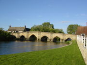
Many of the present road bridges on the river are on the site of earlier fords, ferries and wooden structures. The earliest known major crossings of the Thames by the Romans were at London Bridge and Staines Bridge. At Folly Bridge in Oxford the remains of an original Saxon structure can be seen, and mediaeval stone structures such as [[Newbridge, Oxfordshire and Abingdon Bridge are still in use. Kingston’s growth is believed to stem from its having the only crossing between London Bridge and Staines until the beginning of the 18th century. During the 18th century, many stone and brick road bridges were built from new or to replace existing structures both in London and along the length of the river. These included Putney Bridge, Westminster Bridge, Windsor Bridge and Sonning Bridge. Several central London road bridges were built in the 19th century, most conspicuously Tower Bridge, the only Bascule bridge on the river, designed to allow ocean going ships to pass beneath it. The most recent road bridges are the bypasses at Isis Bridge and Marlow By-pass Bridge and the Motorway bridges, most notably the two on the M25 route Queen Elizabeth II Bridge and M25 Runnymede Bridge. The development of the railway resulted in a spate of bridge building in the 19th century including Blackfriars Railway Bridge and Charing Cross (Hungerford) Railway Bridge in central London, and the spectacular railway bridges by Isambard Kingdom Brunel at Maidenhead Bridge, Gatehampton Railway Bridge and Moulsford Railway Bridge.
The world’s first underwater tunnel was the Thames Tunnel by Marc Brunel built in 1843 and used to carry the East London Line. The Tower Subway was the first railway under the Thames, which was followed by all the deep-level tube lines. Road tunnels were built in East London at the end of the 19th century, being the Blackwall Tunnel and the Rotherhithe Tunnel, and the latest tunnel was the Dartford Crossing.
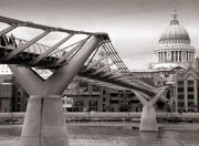
Many foot crossings were established across the weirs that were built on the non-tidal river, and some of these remained when the locks were built – for example at Benson Lock. Others were replaced by a footbridge when the weir was removed as at Hart’s Weir Footbridge. Around the year 2000 AD, several footbridges were added along the Thames, either as part of the Thames Path or in commemoration of the Millennium. These include Temple Footbridge, Bloomers Hole Footbridge, the Hungerford Footbridges and the Millennium Bridge, all of which have distinctive design characteristics.
Some ferries still operate on the river. The Woolwich Ferry carries cars and passengers across the river in the Thames Gateway and links the North Circular and South Circular roads. Upstream are smaller pedestrian ferries, for example Hampton Ferry and Shepperton to Weybridge Ferry the last being the only non-permanent crossing that remains on the Thames Path.
Sport[]
There are several watersports prevalent on the Thames, with many clubs encouraging participation and organising racing and inter-club competitions.
Rowing[]
London
Cambridge cross the finish line ahead of Oxford in the 2007 Boat Race, viewed from Chiswick Bridge
The Thames is the historic heartland of sport rowing in the United Kingdom. There are over 200 clubs on the river, and over 8,000 members of thAmateur Rowing Association]] (over 40% of its membership). Most towns and districts of any size on the river have at least one club, but key centres are Oxford, Henley-on-Thames and the stretch of river from Chiswick to Putney.
Two rowing events on the River Thames are traditionally part of the wider English sporting calendar:
The University Boat Race is rowed between Oxford University Boat Club and the Cambridge University Boat Club in late March or early April, on the Championship Course from Putney to Mortlake in the west of London.
Henley Royal Regatta takes place over five days at the start of July in the upstream town of Henley-on-Thames. Besides its sporting significance the regatta is an important date on the English Season (society) alongside events like Royal Ascot and Wimbledon.
Other significant or historic rowing events on the Thames include:
- The Head of the River Race and other head races over the The Championship Course
- The The Wingfield Sculls for the amateur sculling championship of the Thames and Great Britain
- Doggett’s Coat and Badge for apprentice watermen, one of the oldest sporting events in the world
- Henley Women’s Regatta
- The Henley Boat Races for the Women’s and Lightweight crews of Oxford and Cambridge Universities
- The Oxford University bumps race known as Eights Week and Torpids
Other regattas, head races and bumping races are held along the Thames which are described under Rowing on the River Thames.
Sailing[]
Thames Raters at Raven’s Ait, Surbiton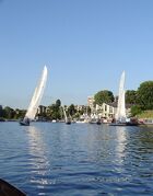
Sailing is practiced on both the tidal and non-tidal reaches of the river. The highest club upstream is at Oxford. The most popular sailing craft used on the Thames are laser (dinghy), GP14 (dinghy), and Wayfarer (dinghy). One sailing boat unique to the Thames is the Thames A Class Rater (scow) which is sailed around Raven’s Ait.
Skiffing[]
Skiffing remains popular, particularly in the summer months. Several clubs and regattas may be found in the outer suburbs of west London.
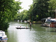
Punting[]
Unlike the «pleasure punting» common on the River Cherwell in Oxford and the River Cam in Cambridge, punting on the Thames is competitive and uses narrower craft.
Kayaking and canoeing[]
LondonKayaking and canoeing are popular, with sea kayakers using the tidal stretch for touring. Sheltered water kayakers and canoeists use the non-tidal section for training, racing and trips. Whitewater playboating, and Slalom canoeing paddlers are catered for at weirs like those at Hurley Lock, Sunbury Lock and Boulter’s Lock. At Teddington just before the tidal section of the river starts is Royal Canoe Club, said to be the oldest in the world and founded in 1867.
Meanders[]
A Thames meander is a long-distance journey over all or part of the Thames by running, swimming or using any of the above means. It is often carried out as an athletic challenge in a competition or for a record attempt.
Culture[]
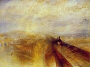
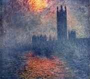
The first Westminster Bridge as painted by Canaletto in 1746. Maidenhead Railway Bridge as Turner saw it in 1844 Monet’s Trouée de soleil dans le brouillard, Houses of Parliament, London, Sun Breaking Through the Fog, 1904 Whistler’s Nocturne in Blue and Gold: Old Battersea Bridge (c. 1872-1875) St John’s lock, near Lechlade. The River Thames in Oxford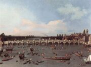


Visual arts[]
The River Thames has been a subject for artists, great and minor, over the centuries. Four major artists with works based on the Thames are Canaletto, J. M. W. Turner, Claude Monet, and James McNeil Whistler. The 20th century British artist Stanley Spencer produced many works at Cookham.
The river is lined with various pieces on sculpture, but John Kaufman’s sculpture The Diver:Regeneration is actally sited in the Thames near Rainham.
Literature[]
The Thames is mentioned in many works of literature including novels, diaries and poetry. It is the central theme in three in particular:
Three Men in a Boat by Jerome K. Jerome, first published in 1889, is a humorous account of a boating holiday on the Thames between Kingston and Oxford. The book was intended initially to be a serious travel guide, with accounts of local history of places along the route, but the humorous elements eventually took over. The landscape and features of the Thames as described by Jerome are virtually unchanged, and enduring humour has meant that it has never been out of print since it was first published.
Charles Dickens Our Mutual Friend (written in the years 1864–65) describes the river in a grimmer light. It begins with a scavenger and his daughter pulling a dead man from the river near London Bridge, to salvage what the body might have in its pockets, and heads to its conclusion with the deaths of the villains drowned in Shepperton Lock/Plashwater Lock upstream. The workings of the river and the influence of the tides are described with great accuracy. Dickens opens the novel with this sketch of the river, and the people who work on it:
In these times of ours, though concerning the exact year there is no need to be precise, a boat of dirty and disreputable appearance, with two figures in it, floated on the Thames, between Southwark Bridge which is of iron, and London Bridge which is of stone, as an autumn evening was closing in.
The figures in this boat were those of a strong man with ragged grizzled hair and a sun-browned face, and a girl of nineteen or twenty. The girl rowed, pulling a pair of sculls very easily; the man with the rudder-lines slack in his hands, and his hands loose in his waisteband, kept an eager look-out.
Kenneth Grahame’s The Wind in the Willows, written in 1908, is set in the middle to upper reaches of the river. This starts as a tale of gentle anthropomorphic animals «simply messing» about on the water and concludes with the arrogant and anti-social Mr Toad getting his come-uppance on a river barge.
The river almost inevitably features in many books set in London. Most of Dickens’ other novels include some aspect of the Thames. Oliver Twist finishes in the slums and rookeries along its south bank. The Sherlock Holmes stories by Arthur Conan Doyle often visit riverside parts as in The Sign of Four. In Heart of Darkness by Joseph Conrad, the serenity of the contemporary Thames is contrasted with the savagery of the Congo River, and with the wilderness of the Thames as it would have appeared to a Roman soldier posted to Britannia two thousand years before. Conrad also gives a description of the approach to London from the Thames Estuary in his essays Joseph Conrad#On the River Thames|The Mirror of the Sea (1906). Upriver, Henry James’ Portrait of a Lady uses a large riverside mansion on the Thames as one of its key settings.
Literary non-fiction works include Samuel Pepys’ diary, in which he recorded many events relating to the Thames including the Fire of London. He was disturbed while writing it in June 1667 by the sound of gunfire as Dutch warships broke through the Royal Navy on the Thames.
In poetry, William Wordsworth’s sonnet Composed upon Westminster Bridge, September 3, 1802/On Westminster Bridge closes with the lines:
- Ne’er saw I, never felt, a calm so deep!
- The river glideth at his own sweet will:
- Dear God! the very houses seem asleep;
- And all that mighty heart is lying still!
T. S. Eliot references makes several references to the Thames in The Fire Sermon, Section III of The Waste Land.
- Sweet Thames run softly, till I end my song.
- The river bears no empty bottles, sandwich papers,
- Silk handkerchiefs, cardboard boxes cigarette ends
- Or other testimony of summer nights.
and
- The river sweats
- Oil and tar
- The barges drift
- With the turning tide
- Red sails
- Wide
- To leeward, swing on the heavy spar,
- The barges wash
- Drifting logs
- Down Greenwich reach
- Past the Isle of Dogs
The Sweet Thames line is taken from Edmund Spenser’s Prothalamion which presents a more idyllic image:
- Along the shoare of silver streaming Themmes;
- Whose rutty banke, the which his river hemmes,
- Was paynted all with variable flowers.
- And all the meads adornd with daintie gemmes
- Fit to deck maydens bowres
Also writing of the upper reaches is Matthew Arnold in The Scholar Gypsy:
- Crossing the stripling Thames at Bab-lock-hythe
- Trailing in the cool stream thy fingers wet
- As the slow punt swings round
- Oh born in days when wits were fresh and clear
- And life ran gaily as the sparkling Thames;
- Before this strange disease of modern life.
Science-fiction novels make liberal use of a futuristic Thames. The utopian News from Nowhere by William Morris is mainly the account of a journey through the Thames valley in a socialist future. The Thames also features prominently in Philip Pullman’s His Dark Materials trilogy, as a communications artery for the waterborne Gyptian people of Oxford and the Fens.
In The Deptford Mice trilogy by Robin Jarvis, the Thames appears several times. In one book, rat characters swim through it to Deptford.
Music[]
The Water Music composed by George Frideric Handel premiered in the summer of 1717 (July 17, 1717) when George I of Great Britain requested a concert on the River Thames. The concert was performed for King George I on his barge and he is said to have enjoyed it so much that he ordered the 50 exhausted musicians to play the suites three times on the trip.
The Sex Pistols played a concert on the Queen Elizabeth Riverboat on June 7, 1977, the Queen’s Silver Jubilee year, while sailing down the river.
Cinema and television[]
A boat chase on the Thames forms the long opening scene of the James Bond film The World Is Not Enough. The offices of MI6, Britain’s external spy agency, are right on the river in a building known as Vauxhall Cross.
The theme of the Thames being completely drained was used in the Doctor Who episode «The Runaway Bride». This theme was also used in the Hollywood Blockbuster Fantastic Four: Rise of the Silver Surfer (2007), where a huge hole in the riverbed beside Westminster Bridge and the London Eye stranded the items formerly floating on the river. The river was traversed in an episode of Top Gear season 10 episode 5. A birds eye view version can be seen in the main titles of EastEnders.
External links[]
- Thames Pilot [2]
London
- ↑ P. Needham (1985) Neolithic And Bronze Age Settlement On The Buried Floodplains Of Runnymede Oxford Journal of Archaeology 4
- ↑ Lamdin-Whymark, H, 2001 ‘Neolithic activity on the floodplain of the river Thames at Dorney’, Lithics 22,
- ↑ Gaius Julius Caesar De Bello Gallico
- ↑ Stephen Oppenheimer The Origins of the British
- ↑ Frost Fairs, London, UK. BBC. Retrieved on March 21, 2007.
- ↑ London, River Thames and Tower Bridge. VR London. Retrieved on March 21, 2007.
- ↑ Environment Agency (2005). Jubilee River.
- ↑ 8.0 8.1 Mallory, J.P. and D.Q. Adams. The Encyclopedia of Indo-European Culture. London: Fitzroy and Dearborn, 1997: 147.
- ↑ 9.0 9.1 See Wikipedia page [3]
- ↑ See Wikipedia page [4]
- ↑ Henig M. & Booth P. 2000, Roman Oxfordshire, pgs.118-9
- ↑ Culteral Heritage Resources (2005). [http://chr.org.uk/legends.htm Legendary Origins and the Origin of London’s place name.
- ↑ Salters Steamers website
- ↑ French Brothers website
- ↑ Floating Down the River website
- ↑ [http://news.bbc.co.uk/1/hi/england/1739401.stm BBC News Wednesday, 2 January, 2002, ‘’Thames lifeboat service launched’’.
- ↑ Port of London Authority. Terminal locations. Archived from the original on May 27, 2008. Retrieved on 2008-05-12.
- ↑ Port of London Notice to Mariners No. 14 of 2006, River Thames Speed Limits